BUS STORY # 413 (Plan Your Ride)

I still remember the time I planned a one-day “in and out” trip to Seattle using only the public transportation system. Since there would be no time lost or saved, it seemed like a perfect opportunity to experiment, and also to save myself the expense (and headache) of renting a car. Why not try taking the bus?
I remember bringing up the King County Metro website and being flabbergasted they had a trip planning program; just type in where you were coming from and where you were going to, and the website told you what bus to catch when and where. Amazing!
Even more amazing: it worked!
I returned to Albuquerque thinking how much more likely a trip planner would make using the bus here.
At the time I started riding, ABQ RIDE was not as new-rider friendly as it is now. I’d been using the system almost exclusively for getting to work in the various areas around town, and by now I knew my routes by heart. But learning and initially using those routes was something different.
I recalled how difficult and anxiety-laced my experience had been figuring out those routes, first in planning the route from the different schedules (which, on line, could not be placed next to one another to match arrival and departure times), and then actually using the bus the first few times on an unfamiliar route. Keep in mind that our annunciator system was not as advanced as it is now. You had to keep a sharp eye on the street signs and have some idea of where your stop was.
And then, we got a trip planner.
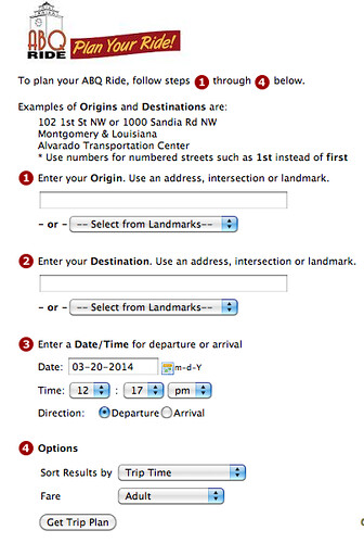
I’m sure I was one of the first users because of the great experience I’d had with Seattle’s Metro. Unfortunately, our new trip planner was a good deal clunkier than Seattle’s. And there were bugs.
On the positive side, ABQ RIDE invited people to point out the problems. I did mine, and they were fixed. And I got a thank you from ABQ RIDE for taking the time to point out the problems. There was no question ABQ RIDE wanted the system to work.
Last summer, in San Francisco, I learned the marvelous smart phone resource of Google Maps for using public transportation wherever you found yourself. San Francisco was a great place to discover the app: we had options for rides just minutes apart. MUNI and Google Maps were magic!
Today, ABQ RIDE has three trip planning resources: it’s own trip planner, Google Maps, and HopStop.

Of the three, the ABQ RIDE app is the clunkiest, but now that I know its idiosyncrasies, and also that it is reliable, it is my go-to app for planning a trip from home. Google Maps is for everywhere else. And HopStop I would have considered superfluous until I discovered it has capacities the other two don’t.
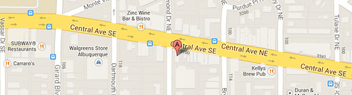
I was meeting a former co-worker and fellow retiree for lunch one Wednesday at O’Neill’s Pub on Central, where there is a good selection of beers on tap and one of the best green chile cheeseburgers in the city.
We were meeting at 11:30, and I already knew my route: take the 11 to Louisiana, then the Red Line to Nob Hill, then the 66 back to O’Neill’s. All I needed was the time I should catch the 11.
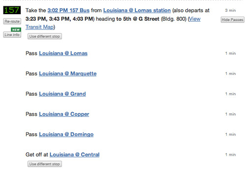
To my great surprise, neither the ABQ RIDE trip planner nor Google Maps had a route using the Rapid Ride. HopStop did. And they even had a second option where I could take the 157 instead of the Red Line.
Who knew?
There’s something else HopStop does. It provides a detailed stop-by-stop route. This is useful if your stop is not one of the major intersections. Using HopStop, you can count the number of stops between the last major intersection and your middle-of-the-route stop, then just count off the stops as they roll by. Or you can get the name of the street at the stop before yours and watch for it.
Google Maps does something similar in that it shows blue icons for the bus stops themselves. You can manipulate the map to see the same things HopStop shows you on a list, and calculate your stop accordingly.
All in all, these apps have made using public transportation in Albuquerque pretty easy. I use them for almost every trip I make that isn’t one of my same-time-same-station runs.
Thank you, ABQ RIDE.
posted by Busboy at 5:00 AM
![]()

1 Comments:
I received this email from a regular reader who invited me to share it in the comments section. Thanks, Gene!
“I want to thank you for the story...on using trip planning [software] in several cities. I asked my wife if our Boston MBTA had that and she said no. I went to their website and lo & behold it did have Rider Tools with an entry for Trip Planner and Start / End like Google Map[s]...
I put in a start time from here (30 miles south of Boston...for catching a local commuter train and end location that would require catching a train and another further away. Up came a itinerary, times for trains & buses that was on the mark!
Thanks for the advice, hints and tip to try it out: -)” -- Gene
Post a Comment
<< Home